Planners, engineers and land developers often need photogrammetry surveys for large areas of land. Data obtained from Photogrammetry Surveys are benecial to the government agencies, the mining industry, oil and gas, property and infrastructure as well as plantations.
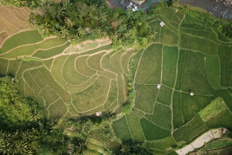
The use of aerial photogrammetry provides an advantage to the design and construction of pipeline work, railroads, highways and locating possible areas to situate new structures such as oil bearing structures for the oil and gas industry as Aerial Photogrammetry Survey constructs a three-dimensional point cloud used to generate the same topographic maps, digital terrain models, meshes, and orthophotos that architects and engineers rely on for design and build work.
UAV measured surveys is extensively used in construction sites, land, quarries, mines and other areas where this remote technique can replace the need for staff on the ground, reducing health and safety risks and lowering costs.
Planners, engineers, government agencies, and developers utilize UAV qualitative datasets. Property and Infrastructure, the Government, Agriculture and Plantations, Utilities, Oil and Gas industries benet from UAV mapping especially in making well-informed decisions in regards to real estate and infrastructure construction management.
Airborne laser proling produces data which are benecial to professional ranging from civil engineers and forestry engineers to archaeologists and geologists by producing Topographic data and deformation monitoring.
Airborne laser proling is also able to produce clear proes of landscapes used for design and planning purposes, providing measurements of land surface features. It is also benecial for a wide range of industries, namely, the Mining, Infrastructure, Urban Planning, Property and Infrastructure, Government, Plantation, and Environmental Industries.
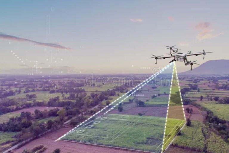
UAV mapping (also called drone mapping or UAV surveying) is the process of using unmanned aerial vehicles equipped with cameras or LiDAR sensors to capture aerial data of a site, which is then processed into georeferenced maps, orthomosaic images, digital elevation models (DEM), and 3D point clouds. In Malaysia, UAV mapping is widely used for topographic surveys, construction site monitoring, agricultural land assessment, infrastructure planning, and slope stability monitoring. It is particularly effective for large or difficult-to-access areas where ground-based surveys are slow, costly, or unsafe.
When conducted with RTK or PPK GNSS correction and properly distributed ground control points (GCPs), UAV photogrammetry achieves horizontal accuracy of 2–3 cm and vertical accuracy of 3–5 cm. For most construction, earthworks, and infrastructure planning applications in Malaysia, this level of accuracy meets engineering requirements. Accuracy is influenced by flight altitude, camera resolution, GSD (Ground Sample Distance), and site conditions. Higher-precision projects may combine UAV data with total station or GNSS control measurements for verification.
UAV mapping using photogrammetry captures images processed into orthomosaics and DEMs — it is cost-effective, fast, and well-suited for open terrain, construction sites, and agricultural land. LiDAR (airborne laser profiling) uses laser pulses to generate dense 3D point clouds and can penetrate dense vegetation, making it the preferred method for forested areas, corridor mapping, and terrain modelling beneath tree canopy. LiDAR delivers higher point density and works in low-light conditions, but costs more than photogrammetry. For most Malaysian projects, UAV photogrammetry is chosen for open sites while LiDAR is specified for jungle terrain, railway corridors, and pipeline routes.
Yes. Commercial UAV operations in Malaysia — including UAV mapping and aerial survey — require authorisation from the Civil Aviation Authority of Malaysia (CAAM) under Regulation 189 of the Malaysian Aviation Commission Act. Operators must hold a valid CAAM Remote Pilot Licence (RPL) and obtain operational approval before conducting survey flights. Aerial photography and mapping activities additionally require an approval letter from the Department of Survey and Mapping Malaysia (JUPEM), which charges a processing fee of RM50. Engaging a licensed surveying company ensures all regulatory requirements are handled as part of the service.
Standard deliverables from a UAV mapping project include: georeferenced orthomosaic images (high-resolution aerial plan view), Digital Elevation Models (DEM) or Digital Surface Models (DSM), contour maps, and a survey accuracy report. For construction and engineering projects, additional outputs include volume calculations (cut and fill), stockpile measurements, slope analysis, and CAD-compatible terrain data. For LiDAR-based aerial surveys, deliverables include classified 3D point clouds and bare-earth terrain models. The specific deliverable format (DWG, GeoTIFF, LAS, PDF) is agreed with the client based on project requirements.
A single UAV flight can survey approximately 40 to 200 hectares per day depending on the aircraft type, flight altitude, required GSD, and battery capacity. Fixed-wing UAVs cover larger areas efficiently — suitable for corridor surveys and large plantation mapping — while multi-rotor UAVs offer greater flexibility and precision for smaller, complex sites. LiDAR-equipped fixed-wing UAVs can survey up to 10 square kilometres in a single flight. For projects requiring national or regional coverage, manned aircraft or satellite imagery is typically used instead.
GSD is the distance between two consecutive pixel centres measured on the ground — it determines the spatial resolution of the aerial imagery. A lower GSD value means higher resolution and more detail. In UAV mapping, typical GSD values range from 2 to 5 cm per pixel at standard survey altitudes. A GSD of 2 cm means each pixel in the orthomosaic represents a 2 cm × 2 cm area on the ground. GSD directly affects map accuracy and the level of detail visible — critical for applications like boundary verification, road design, and site as-built documentation.
Yes. UAV mapping is one of the most efficient methods for volumetric calculations in Malaysia, widely used for earthworks monitoring, quarry stockpile management, and cut-and-fill quantity verification. Using point cloud or DEM data generated from UAV survey flights, surveyors can calculate stockpile volumes with approximately 1–2% accuracy compared to manual measurement methods. Regular UAV flights over the same site allow progress monitoring and volume tracking over time, reducing the need for manual site visits and improving contractor accountability.
UAV mapping is preferred over traditional ground surveys when: the project area exceeds 5 hectares and speed is important; the terrain is difficult or hazardous for ground crews (steep slopes, active construction zones, or remote jungle); a complete surface model is needed rather than selected spot heights; or regular repeat surveys are required for progress monitoring. Traditional ground surveys with GNSS and total stations remain more appropriate for precise boundary demarcation, legal cadastral surveys, and small-scale detail work requiring sub-centimetre accuracy. For most Malaysian infrastructure and construction projects, UAV mapping and ground control are used together.
Cadastral Survey
Aerial Mapping Survey
Engineering Survey
Hydrographic Survey
Underground Utilities
Detection & Mapping
Geographical Infomation System (GIS)
Terrestrial Laser Scanning
Mobile Mapping System (MMS)
Building Information Modelling (BIM)
3D Laser Scanning Services
As-Built Survey Services
Topographical Survey
Kuala Lumpur
Suite L11-21, Tower 1, Wangsa 118, No.8, Jalan Wangsa Delima, Wangsa Maju, 53300, Kuala Lumpur
T :+(6)03-4144 2344
T: +(6)0386878415
F :+(6)03-4144 2644
E: sgskl@setiageosolutions.com
Whatsapp : +(6)0386878415
© 1959 – 2026. Setia Geosolutions Sdn. Bhd. (ISO 9001:2015 Certified Company). All Right Reserved | Powered by keepdesign
No.152A, Jalan Tasek Timur,
Pusat Perdagangan Tasek Indra,
31400 Ipoh, Perak Darul Ridzuan