Hydrographic Survey

About Hydrographic Survey

Hydrographic Surveys is utilized for the purpose of determining the topography of seabed, river beds, lakes or any other waterbodies in relation to the foreshore, pier, jetty, or shorelines. Hydrographic Surveying is a survey methodology that is concerned with the detailed 3D underwater (ponds, rivers, lakes and oceans) bed models derived from bathymetric surveys using GNSS controlled hydrographic survey equipment. This survey method provides detailed information on water depth soundings, shorelines, tides, currents, sea floor and submerged obstructions. This survey method is also used to produce a seabed profile for further long-term planning. Setia Geosolutions implement large scale and small scale hydrographic survey projects for governmental and private sector clients

Hydrographic survey plans are drawn to suitable scales and is utilized by engineers to prepare engineering designs for submission to the relevant authorities for approval. The high resolution
hydrographic information in the form of seabed imagery provides a basis for oil and gas or utility industries to make decisions on matters such as where to locate subsea installations such as pipelines or communications cables.

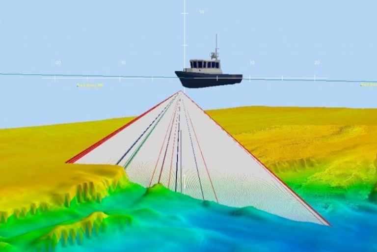
Hydrographic information is highly useful for resource development, marine construction, transportation planning, as well as Oil and Gas exploration. This survey method also provides coastal mapping for projects involving coastal and waterfront developments.

List of Experience :

  • Hydrography Survey Works On Construction of New Jetty for Marine Park Center Project at Pulau Tinggi, Mersing, Johor.
  • Hydrographic Survey Works For Proposed Bridge Crossing Sg. Pulai And Link Road From Pelabuhan Tanjung Pelepas To Tg. Bin, Mukim Air Masin And Sg. Karang, Daerah Pontian And Mukim Pulai, Daerah Johor Bahru, Johor Darul Takzim.
  • Hydrography Survey At Mukim Batang Berjuntai, Mukim Pasangan, Mukim Tanjung Karang And Mukim Ulu Tinggi, Daerah Kuala Selangor, Selangor Darul Ehsan.
  • Seabed Profile And Hydrology Study And Ground Investigation For Proposed Submarine Cable Route From Kapar Power Station To Pulau Ketam, Selangor.
  • Proposed Development Of The Ledang District New Administrative Centre Mukim Tangkak, Muar, Johor Darul Takzim (LDNAC).
  • In-Situ Measurement of Warm Water Re-circulation at Tuanku Jaafar Power Station, Port Dickson, Negeri Sembilan.
  • Kerteh Port Marine Facilities Expansion Works, Kerteh, Terengganu-Water Sampling Monitoring & Beach Profiling.
  • Feasibility Study for the Proposed Ethylene/Polythylene Project, Kerteh, Terengganu.
  • Proposed Hydrography Survey Works for Sg Golok Flood Mitigation Project (KESBAN).
  • Proposed Construction of Wharf/Quary for Oilab Fabrication Yard Fronting at Pulau Indah.